


Project Overview
To expand and refine Fenland SOIL’s landscape opportunity mapping technique to four new internal drainage boards across the Fens.
To explore the feasibility of including commercial-scale paludiculture on an intensive vegetable farm.
Fenland SOIL:
Fenland SOIL was set up in 2021 by the Cambridgeshire and Peterborough Combined Authority’s Independent Commission on Climate with a team of dedicated farmers at its core to tackle climate issues relating to agriculture and peat in the Fens. We are a not for profit members organisation that aims to inform and develop ‘whole farm’ land use policies, aimed at achieving climate change mitigation and biodiversity enhancement in the fens, and to help establish an agreed set of numbers for GHG emissions for deep, shallow and wasted peat soils. We have been achieving this through a series of grant funded projects with one of these being the Paludiculture Exploration Fund.

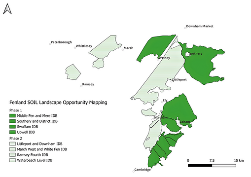
Landscape opportunity mapping
Fenland SOIL’s landscape opportunity mapping workstream is aiming to increase understanding of the condition of Fenland soils including drainage status, soil properties and peat depth and to identify future landscape management opportunities. We are carrying out a farmer-led mapping phased approach that utilises farmer and landowner knowledge of soil types, agricultural productivity and water management at a field scale within Middle Fen & Mere (8244 ha), Southery & District (9790 ha), Swaffham (5234 ha) and Upwell (4847 ha) IDBs with the addition of Waterbeach Level (2720 ha), Littleport & Downham (13,048), Ramsey Fourth (1503 ha) and March West & White Fen (4368 ha) IDBs this year.
The use of local soil knowledge is supported with ground truthing. Fenland SOIL field staff select a representative sample of fields within each farm to survey. 70mm cores were taken using a combination of Dutch and gouge augers by one of the surveyors to a minimum depth of 1m. Surveyors continue to core beyond 1m where there is peat present or expected and ceased augering at 1m in the absence of peat.
For each auger hole soil type, horizon depth, and Munsell colour values are recorded. Soil samples are also sent to a laboratory for analysis specifically for organic matter (OM) content. The data collected contributes directly to the England Peat Map.
The information is used to create a series of opportunity maps for each district which can be used by farmers and land managers to identify potential opportunities for sustainable management of peat soils within the Fenland landscape. These potential opportunities could include sustainable peatland farming (regenerative farming), wetter farming (paludiculture) or peatland restoration.

Paludiculture trials
Through the PEF project, Fenland SOIL has run a 3-hectare paludiculture trial on G’s Norfolk Farms in an intensive salad cropping system. The site was chosen because of the hydrological infrastructure in place on the farm. The site is in close proximity to a river and a reservoir for a sufficient water supply. The site is surrounded by two IDB drains that feed water from the River Wissey through a water inlet along a drain to a dam. This allows the ability to alter the water table as needed. There are also in-field land drains at 10 metre spacings across the field. The water table depth was measured throughout the growing period and held between 10-30cm.
The crops we have grown are celery, Chinese leaf, miscanthus and lettuce. These crops were chosen because they were already grown on the farm, but also because they are shallow-rooting and tolerant to high water tables. The trial site and control fields were both monitored by UKCEH for carbon dioxide, methane and nitrous oxides. The beds were prepared beforehand, including the fields being laser levelled before the water table was raised. The tramlines were drilled with a rye mix to provide stability for the crops to be sprayed. Last year’s trial, the crops were harvested by hand. This year, the water level was dropped before harvest so we could get a lettuce rig onto the field. In light of our paludiculture trial, we are in the process of writing a report assessing the economic and risk analysis of paludiculture cropping at farm and Fenland scale.
Water table modelling
In collaboration with Fenland SOIL, Professor Ian Holman of Cranfield University has modelled water tables across Middle Fen & Mere, Southery & District, Swaffham and Upwell IDBs and created a report on water table modelling and emissions. The water table depth in lowland agriculture peats is a consequence of space and time varying consequences between the balance of inflows and water outflows within the constraints of drainage controls. To model this drain water level elevation were estimated using the Environment Agency Lidar point cloud data. Then daily water table depths were simulated taking into account freeboard, landcover using the WaSim Model and drain spacing. Finally, carbon dioxide and methane fluxes were calculated using annual average effective water table depth for each field using regression equations.

Main Findings
Landscape Opportunity Mapping
The project demonstrates that our landscape opportunity mapping is an effective tool for identifying potential opportunities at a field scale for sustainable peat farming, paludiculture and peatland restoration across the fenland landscape. To date, over 30,000 ha have been mapped, comprising 4,430 ha of deep peat, 9,335 ha of shallow peat, 5,111 ha of organo-mineral soils, and 11,309 ha of mineral soils. The next steps are to complete the mapping of the remaining IDBs within the fens. Specifically focusing on mapping the South Level while collaborating with the South Level Water Project and continuing to integrate our data into the England Peat Map.


Paludiculture Trials
Our paludiculture trial demonstrated that intensive salad crops can be grown with a higher water table, though water management and operation issues reduced yields. Maintaining a consistent 10–30 cm water table was difficult due to field topography, rainfall variability, and water abstraction limits. For future trials we are going to lower the water table to 30–50 cm and continue to test other arable crops.
Emissions & Yield
Under paludiculture:
-
CO₂ emissions fell by 38% (celery) and 47% (Chinese leaf)
-
CH₄ emissions rose by 11.8% and 84%, the site is a net CH₄ emitter after 3 October
-
N₂O emissions dropped by 90% in celery, no change in Chinese leaf
-
Yield quality declined: Chinese leaf 50% packing quality vs 65% control, celery 34% vs 85% control
In this trial, comparing paludiculture with conventional cropping, showed significant greenhouse gas (GHG) emission reductions—up to 47%—but also substantial yield losses and financial impacts. Chinese leaf and celery experienced the greatest economic challenges, with estimated losses of £300,000 and £3.3 million respectively if applied across entire farms. Lettuce trials revealed variable results, with losses ranging from £6,359 to £21,172. To maintain current production levels, land requirements would increase by 30% for Chinese leaf and 250% for celery, highlighting the trade-offs between environmental benefits and economic viability (Table 1).

Table 1: Paludiculture Performance: Environmental Gains vs. Economic Costs in intensive salad crop trials. Watertable depth 10 to 30 cm
Partners - Fenland SOIL
Fenland SOIL is a not for profit members organisation that aims to inform and develop ‘whole farm’ land use policies, aimed at achieving climate change mitigation and biodiversity enhancement in the Fens, and to help establish an agreed set of numbers for GHG emissions for deep, shallow and wasted peat soils.
Fenland SOIL was set up in 2021 as part of the work carried out by the Cambridgeshire and Peterborough Combined Authority’s Independent Commission on Climate as a dedicated team with farmers at its core to tackle climate issues relating to agriculture and peat in the Fens. We hope that by acting as a united front and showing proactivity we will be able to positively influence and help shape policy so that it is fair and realistic for those that will be implementing it. We feel that ‘the best defence for farming is to stop being so defensive’.
Email: info@fenlandsoil.org
Partners


